Saturday, August 18, 2007

Home sweaty home


Wee're Baaack...

We made it home, all pieces and parts intact. Huge sense of Deja-vu on the last day. Last year, as we exited a freeway 150 miles from home, we saw a smoke plume for the Day fire. This year, same spot, much bigger plume from the Zaca fire. Guess we all know where Tom is going.

27 days

7,859 miles

3 tired people.

And somebody replaced our puppy with a full-grown dog while we were gone!

Friday, August 17, 2007

heading home


So much for fun. We now have to do the serious "heading home". As we left beautiful Kaibib plataeu, the sky got dark, the clouds threatened, and up came the wind. We battled some impressive winds and thunderstorms to make it to our last night's stop.

Grand Canyon


So where did we go? We went to the North Rim of the Grand Canyon. Why the North Rim? It's much higher than the south rim, and much less "touristy". Only 10 miles as the condor flies from tourist central on the south rim, it's over 200 miles away by ground. (Unless you hike all the way down and all the way back up. We didn't do that.)

It was truly impressive, even to a 4-year old.

oops again


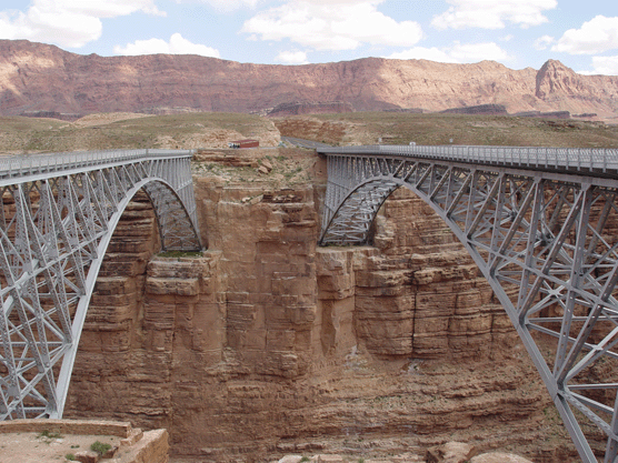
Here's the picture from the bridge. It was SCAARRRAAYYY on the bridge.
Next we stopped in a backcountry campground overnight and did a short hike. Miles decided on how we would carry our hiking sticks.


We were treated to a couple Arizona monsoon thunderstorms. They were all far in the distance, so the New York thunderstorm is still WAAAY better.

Miles slept through this one too.

Where have we been?

Did you miss us? We got fed up with the boring interstate and decided to take one last detour. First we drove across this bridge and took a couple pictures.

OOPS

Yesterday, as we tooled through the backcountry of northern Arizona, SOMEBODY decided to do some camera maintenance. SOMEBODY decided to push one too many buttons. SOMEBODY wiped out 2/3rds of all pictures we have taken on this vacation.

This same SOMEBODY has contemplated suicide several times since then, the partner has disuaded her/him.

We still have the memories. Those can never be erased.

Tuesday, August 14, 2007

Be careful what you wish for... (I wanted a smart kid)

Grandma Campaney was nice enough to give us the family "Trouble" game - an original that still has all its pieces. And she taught Miles how to play. Trouble is now a nightly tournament on the trip.

The little @$%&&^ has won 80% of all games played. Sara? 0%

In desperation, we taught him Bingo last night.

The little @$#%@&%^% won all 4 games.

Next time, we let Grandpa teach him poker, and we'll stop in Vegas on the way back.

Mapping software (geeks only)

Okay, so I'm (Tom) a techno-geek, right? I admit it. GPS-based navigation has long been a part of my travels. Last year I ran my tablet PC with a couple different programs on it, each one with its own flaws. Read last years blog if you're a geek.

Before this trip I wanted an updated mapping program. My old standby is Garmin's "NRoute" - it works great in and around Ventura County. I used it for 2 years on my old P.O.S. laptop in my work truck. But it cannot be updated, it will not import POI files, and it has a clunky interface. To top it off, it will display only the most major highways, and at a false scale. But if you route using it, it "magically" learns the correct route and displays it. To me, that means it has the real roads in it, but only displays a "dumbed-down" interface. Lousy design.

Last year I tried Microsoft Streets and Trips, but hated their interface too. This year I found the latest Delorme Street Atlas 2008. I've liked Delorme in the past, so we bought SA08. It even had the extra benefit of understanding my 'hockey puck' Garmin GPS18 USB antenna - last year nobody other than Garmin could use it, until I installed a hack.

The trip planning functions on it work well. You can tell it what roads you prefer. You can add POI (point of interest) files. Some nice people out there have created lots of these files. I can add in the locations of Super WalMarts, Cabelas (my favorites), even low-clearance warnings. All appear if you want them. It updates road construction information (although it has been wrong 100% of the time so far).

BUT...

The damn thing has problems communicating with the Garmin antenna. Every once in awhile it just shuts down and swears to me that no antenna is attached. Or, it will say, "Yup, antenna is working just great, boss" while claiming I am moving down the freeway at 0 mph.

Then to top it off, first I dropped the damn tablet PC. The screen still works, you just have to look behind the cracked glass. Then the tip fell out of the stylus somewhere in Minnesota. Now I am using a mouse with it. And it still drops the antenna.

So here is the current setup: Use the tablet with Delorme SA08 for trip planning each night. Have it map out several options for distance and travel. Pick our final destination with it. The next morning, pull out the POS laptop that just keeps slugging along. Fire up Garmin's NRoute software, type in the final destination derived from SA, and drive on down the road. If we need to find out the location of FlyinJ, CampingWorld, etc we have to pull out the other one or rely on the mark1 eyeball (enhanced by binoculars from the copilot seat).

We have succeeded about 80% with teaching Miles what "silent cockpit" means. When entering an area of maneuvers (interchanges, cities, etc) he now knows to keep silent (mostly) in the back. If he ever goes flying with Uncle Dave or Grandpa John, he might just behave.

A quick post for Roy in Texas

Roy knows what these are for. Everybody else disregard.


married too long


You know you have been married to a firefighter for too long when you can spot a brushfire from 5 miles away...

You know you have been married to a firefighter for too long when you can spot a brushfire from 5 miles away...

Anybody mention it is hot?

It is HOT! We chose I-40, not sure it helped. Driving yesterday afternoon, the outside air temp gauge hit 108. We had to run the generator and the house AC just to keep it below 90 in the back. A quick afternoon shower only dropped it to the mid-90's.

Decided to set the alarm clock this morning with the theory that we could get most of our driving in while it was cooler. Ha! At 7:30 this morning it was still 82 outside. Today we find someplace with a pool.

highway funding


One wonders just what Oklahoma has done with their portion of the $286 billion in highway funds, because they sure as heck didn't spend a dime of it repairing their roads. As we rattle and bounce our way across the state, we hope we don't end up looking like this guy.

Monday, August 13, 2007

Tennessee


Found a very nice state park campground last night. Miles had great fun throwing rocks in the creek and feeding the squirrels. It was still in the 80's when we went to bed. It's already 101 today.

NOw we have to decide - take I30 or I40. 30 is flatter, but further south. 40 is hillier, but cooler.